Posted by: HART | 03/27/2013

Hike: Teapot Mountain via Stegosaurus ridge

63973_10151326331076441_285468031_nMap, photo, and description by CU.

Warning: Part of this trail is on controlled land, belonging to state companies. You will want to stay out of sight, especially in the gully, and watch out of the infrared detectors near the white wall. There is a guards’ cabin near the guate.

0800 start, 0830 river dam (*accidently climbed this dam; the correct way is to detour on the right), 0900 finish river tracing, 1000 getting on the ridge (*4km long), 1330 right turn to Mt.Teapot (*if you go straight, you will reach Mt.燦光寮) , 1500 teapot trail parking lot.

Map

GPX: We don’t link to GPX files directly anymore since links get broken whenever Wandermap updates their system. Instead you need to look on the Wandermap page, below the description of the hike, in the right corner for a “Export GPS Data” button. It will then download automatically.

Posted by: HART | 03/04/2013

Hike: Teapot and Banping Mountains

528442_10151393358728138_1454184692_n

Map, description, and photo by Matteo

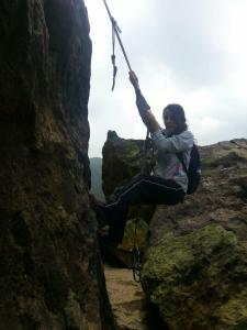
The Teapot Mt. and Banping Mt. hike in northern Taiwan is one of the best, most scenic day hikes one can find on the island. The trail start at the Gold Ecological Park near Jiufen (九份). A series of stairs will bring hikers first to a secondary road, then to the base of the “teapot” peak. Once there, one has to climb through the rocks to the narrow top, negotiate a small chasm to the stone platform to the other side, then follow some more fixed ropes down to the trail to Banping Mt. This second part of the hike is a lovely stretch of steep trail surrounded by tall grass. Some small clearings can be found and are perfect spots for a break or a picnic. At the base of the rocky ridge the last fixed ropes lead to the top of Banping Mt. The climb is very short but fairly slippery, so pay attention here.

480137_10151393360088138_1055159164_n Once on the other side the trail follows the ridge (fixed ropes are there in the trickiest, most dangerous parts), becoming gentler after a while. Its last, overgrown stretch leads to an old road. Once there, one can either turn left, then immediately right to catch the trail to Caiguangliao Mt. (very dangerous if wet!!), or turn right and head back to the Gold Eco Park or road 102 (take the steps going down on the right after a while for the Eco Park).

533154_10151393357233138_154149497_nOnce down the first set of steps, a short detour leads to a somewhat interesting exhausted gold vein which has been excavated when the gold mine was active. The whole hike is ridiculously scenic. At no point will you be able to complain about the view, which includes mountains, valley and the Pacific ocean.

Practicalities: Walking time is about 4 h, including one long stop. Make sure to bring lots of water and sunscreen if hiking in summer, for the trail does not offer any shade. Avoid this hike on a wet day, for there are plenty of places where a slip and a fall could cause severe injuries. Parking is available at the start of the hike (Gold Eco Park).

Weather sensitivity: This hike is good after rain, for it dries fast as it is more exposed. This also means that you will not have much protection if the weather change.

Map page

GPX: We don’t link to GPX files directly anymore since links get broken whenever Wandermap updates their system. Instead you need to look on the Wandermap page, below the description of the hike, in the right corner for a “Export GPS Data” button. It will then download automatically.

Posted by: HART | 02/25/2013

Hike: ShiGuanYingShan loop

Map, description, and photo by Matteo

538171_10151385988198138_977207131_nA steep trek up and down the peaks west of PingXi. This hike covers part of the complex trail network around the PingXi valley: we tried to include a little bit of everything. First, make sure to take a look at the cave behind the temple. Retrace then your steps for some hundred meters and take the trail climbing steeply beyond the strem. The first km is a step ascent from the GuanYing temple to the ShiGuanying peak, from where  one has to scramble down the very steep north-eastern side before meeting the upper end of the YiKeng hystoric trail, that brings the hike through bamboo farms and the fascinating remnants of the coal industry that once flourished here. The last 500m of the trail are a quaint walk on a paved trail through the countryside. Numerous access to the river below allo hikers to take a dip in the refreshing waters in the hot summer months.

A couple of warnings: some parts of this hike are really steep, so make sure you and your fellow hikers have a good head for heights and are familiar with rocky scrambles negotiated with fixed ropes. Also, wear long trousers AND long socks, for leeches are everywhere on this trail and will find their way to your legs easily.

4h are more than enough for this trail, but plan for many stop for there are countless things you might find interesting to enjoy for a while.

Map page

GPX: We don’t link to GPX files directly anymore since links get broken whenever Wandermap updates their system. Instead you need to look on the Wandermap page, below the description of the hike, in the right corner for a “Export GPS Data” button. It will then download automatically.

Photo, map, and description by Matteo.

188266_10151372641738138_1180055725_n

An alternative ascent to the Taoyuan Valley trail, this route is shorter and much much steeper than the one from Dali. The trail is interesting and slightly technical, but care must be taken in some parts that have been damaged by landslides (a sign at the beginning of the trail will suggest hikers to take the much safer trail that starts in Daxi village). This route is though but much more scenic and beautiful. A temple is found at about two thirds of the ascent. It offers food, water, shelter and toilets. Loudspeakers connected to the temple and located some hundred meters below it fill the valley with music that can be heard from the trail since almost the beginning, giving this route a magical, “ascent to Heaven” kind of feeling.

This trail ends at the top, west end of the Taoyuan Valley trail. Turning left one can reach the last gazebo, then start the 5km descent to Daxi. Turning right leads to the Taoyuan Valley trail proper, which ends atop Dali village and connects with the Caoling Hystoric trail leading to Fulong.

Map page

GPX: We don’t link to GPX files directly anymore since links get broken whenever Wandermap updates their system. Instead you need to look on the Wandermap page, below the description of the hike, in the right corner for a “Export GPS Data” button. It will then download automatically.

Posted by: HART | 02/15/2013

Hike: YueMeiKeng Waterfall

Map and photo by Matteo.

59711_10151369225063138_1127343619_nThis is a pretty fantastic hike whose location we are finally making available to everyone (at least in English). Richard Saunder’s has an enticing description over at Taiwandiscovery.

Please make sure to respect the trail, as it is still pristine and pretty fragile.

Map page

GPX: We don’t link to GPX files directly anymore since links get broken whenever Wandermap updates their system. Instead you need to look on the Wandermap page, below the description of the hike, in the right corner for a “Export GPS Data” button. It will then download automatically.

Posted by: HART | 02/11/2013

Hike: JingAn MRT to TuCheng ridge walk

Photo, map, and description by Matteo

An easy yet satisfying hike with a very diverse selection of terrains and trails. It covers part of the ridge that extends from YongHe to Sanxia.543705_10151363290758138_507675990_n This is a short version, doable in under four hours with one long stop for lunch. This hike ends at the ZhongHe Pond, from which one can either take a bus down to TuCheng MRT, call for a taxi or hitch a ride.

Map page

GPX: We don’t link to GPX files directly anymore since links get broken whenever Wandermap updates their system. Instead you need to look on the Wandermap page, below the description of the hike, in the right corner for a “Export GPS Data” button. It will then download automatically.

106B to Pinglin

GPS trace and description by Kirk

It goes out the 106b to Pinglin, then back on highway 9 to Xindian. It’s not for the faint of heart. It’s a very tough ride. 1000 meters of elevation gain in 60k. The climb up up 106b is a category 2 climb, and comes in at 8.6km with an average grade of 5.8%.

Map page

GPX: We don’t link to GPX files directly anymore since links get broken whenever Wandermap updates their system. Instead you need to look on the Wandermap page, below the description of the hike, in the right corner for a “Export GPS Data” button. It will then download automatically.

Posted by: HART | 02/04/2013

Road Ride: North coast 北海岸 Grand Loop

Map by Kirk

North Coast Loop

This is the complete northern coast loop with a departure and arrival in Taipei. Moving time was just over 7 hours, total length just over 170km. The section between Gongliao and Taipei has the most elevation.

Map page

GPX: We don’t link to GPX files directly anymore since links get broken whenever Wandermap updates their system. Instead you need to look on the Wandermap page, below the description of the hike, in the right corner for a “Export GPS Data” button. It will then download automatically.

Jiandao Shi 剪刀石

Map, photo, and description by Matteo.

This is a different hike from the one we posted a while ago, but it also reach Jiandao shi.

We took the trail from Jiannan MRT, exit 1, we reached Jinmian Shan in about 2 hours of slow hiking and we descended behind Xihu MRT. It’s an easy hike of a little less than 7km. Bonus: if you look carefully enough, there is a military bunker that someone forgot to lock on this trail.

Map page

GPX: We don’t link to GPX files directly anymore since links get broken whenever Wandermap updates their system. Instead you need to look on the Wandermap page, below the description of the hike, in the right corner for a “Export GPS Data” button. It will then download automatically.

Posted by: HART | 01/28/2013

Hike: Qixingshan north to south side

Map by Matteo.

75079_10151312939053138_2071531726_n


This is an easy, 6.5k long, hike in Yangminshang, culminating with a 1120m peak. It can get pretty foggy up there.

Map page

GPX: We don’t link to GPX files directly anymore since links get broken whenever Wandermap updates their system. Instead you need to look on the Wandermap page, below the description of the hike, in the right corner for a “Export GPS Data” button. It will then download automatically.

« Newer Posts - Older Posts »

Categories